

![]()
[Mörsburg (134k) | maps | home]
The forest between Welsikon (N), Seuzach (SW) and the Mörsburg castle
(E) is the most important part for the OLG Welsikon in terms of time and
usage.
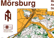
The Mörsburg map was the first o-map drawn by OLG Welsikon in 1976. Since
then it was remapped three times and in between the most important corrections
were overprinted. Reprints are made in 1979, 1986, 1994 and 2002.
Mörsburg is used frequently for trainings because originally most of
the club members were located somewhere around this map.
We provide you a part (2/3) of the issue (1994) here
 Click to
see the full scan (143k) of the Mörsburg
map.
Click to
see the full scan (143k) of the Mörsburg
map.